
Ӳкерчĕк:Madhhab Map2.png
Ҫак умкурӑмӑн виҫи: 800 × 388 пиксел. Ытти разрешенисем: 320 × 155 пиксел | 640 × 310 пиксел | 1245 × 604 пиксел.
Оригиналлӑ файл ((1245 × 604 пиксел, файл пысăкăше: 50 Кб, MIME-тĕсĕ: image/png))

|
Это изображение неизвестного типа «religion map» желательно воссоздать или аккуратно преобразовать в векторный формат SVG. Это даёт несколько преимуществ, прочитать о которых подробнее вы можете на странице Commons:Media for cleanup. Если вам уже сейчас доступна векторная версия данного изображения, загрузите её, пожалуйста, а затем замените этот шаблон на следующий: {{Vector version available|Имя загруженного файла.svg}}.
|
Кĕскен ăнлантарни
| Ӑнлантарни |
العربية: المدارس الفقهية الإسلامية الرئيسيّة وانتشارها حول العالم (لغة إنجليزية)
فارسی: نقشهٔ پراکندگی مذاهب فقهی اسلام در جهان (انگلیسی)
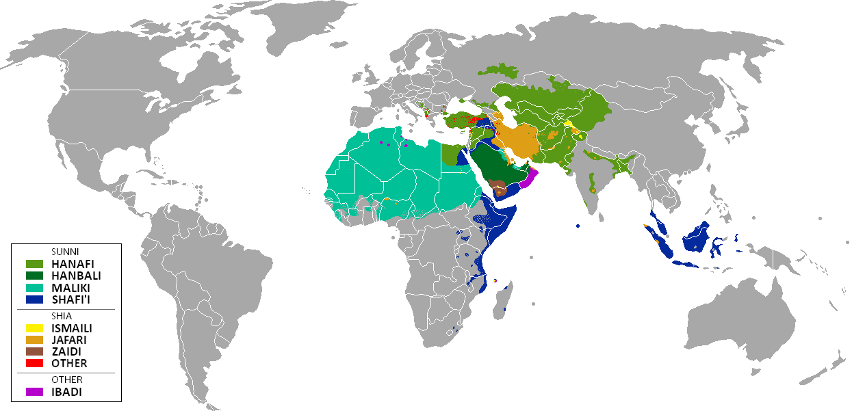
English: The distribution of the predominant Islamic madhhab (school of law) followed in majority-Muslim countries and regions (English)
Bahasa Indonesia: Distribusi penyebaran agama islam berdasarkan Mahdab di negara-negara dan wilayah dunia |
| Дата | |
| Ҫӑлкуҫ | Own work by uploader from a blank-map, based on this source: Legal Sources and various other sources |
| Автор | Ghibar |
| Другие версии |
Derivative works of this file: |
Лицензилени
Я, владелец авторских прав на это произведение, добровольно публикую его на условиях следующих лицензий:
Ку файл Creative Commons Attribution-Share Alike 3.0 Unported лицензипе мкилӗшӳллӗн сарӑлать.
- Эсир ирӗклӗн:
- ку ӗҫе ыттисене тивӗҫтерме – ку ӗҫе копилеме, сарма тата ыттисене пама
- унашкаллисене хатӗрлеме – ку ӗҫе улӑштарма
- Ҫак условисене пӑхӑнсан:
- атрибуци – Сирӗн кам автор пулнине кӑтартмалла, лицензи ҫине каҫӑ памалла та автор мӗнле те пулин улшӑнусем кӗртнипе кӗртменнине палӑртмалла. Ҫакна кирек мӗнле юрӑхлӑ меслетпе те тума пулать, анчах лицензиат сире пулӑшнине е сире асӑннӑ хайлавпа усӑ курма ирӗк панине кӑтартмасӑр.
- ҫав условисемпех сарма юрать – Енчен те эсир асӑннӑ хайлава тӗпе хурса ҫӗннине йӗркелетӗр, улӑштаратӑр, е урӑх хайлав тӑватӑр пулсан, сирӗн тӗпри хайлавӑн лицензипе е унпа пӗрешкеллипе усӑ курма тивет.

|
Ку документа Ирӗклӗ программа хатӗрӗсен фончӗ вырнаҫтарнӑ GNU Free Documentation License 1.2 версийӗпе е каяраххипе килӗшӳллӗн хуплашкан пӗрремӗш тата юлашки страницӑри улшӑнми пайсемсемпе текстсемсӗр копилеме, сарма тата/е улӑштарма юрать. Лицензи копине GNU Free Documentation License ятлӑ пая вырнаҫтарнӑ. |
Эсир ҫак лицензисенчен хӑть те хӑшне суйлама пултаратӑр.
| Annotations | This image is annotated: View the annotations at Commons |
Файл историйĕ
Вӑхӑт ҫине пуссан, ун чухнехи версине пӑхма пулать.
| Дата/Вăхăт | Миниатюра | Калӑпӑш | Хутшăнакан | Асăрхав | |
|---|---|---|---|---|---|
| хальхи | 11:24, 23 Кӑрлач уйӑхӗн 2018 | | 1245 × 604 (50 Кб) | Maphobbyist | Revert. Jafari school more widespread in northern Sumatra according to sources, than mere dots. |
| 11:55, 30 Ҫу уйӑхӗн 2016 |  | 1245 × 604 (2,87 Мб) | Riyantojayadi | Madhhab majority of Aceh region[1] and West Sumatra/Minangkabau region[2] in Indonesia are Syafii school of Sunni. There are some tribe's ritual in this area that are based on Shia such tabot, however, for religion, they are practicing . Shia communiti... | |
| 13:45, 11 Кӑрлач уйӑхӗн 2015 |  | 1245 × 604 (50 Кб) | AnonMoos | Reverted to version as of 02:11, 30 July 2014 -- see User_talk:Peaceworld111 | |
| 10:24, 11 Кӑрлач уйӑхӗн 2015 |  | 1245 × 604 (52 Кб) | Peaceworld111 | Re-added Ahmadi. It's a sect of Islam per reliable sources and is not a mere dot. See talk page. | |
| 02:10, 11 Кӑрлач уйӑхӗн 2015 |  | 1245 × 604 (50 Кб) | AnonMoos | Reverted to version as of 02:11, 30 July 2014 -- change not discussed on image talk page, possibly problematic, see user talk page | |
| 18:11, 8 Кӑрлач уйӑхӗн 2015 |  | 1245 × 604 (52 Кб) | Peaceworld111 | Added Ahmadi | |
| 02:11, 30 Утӑ уйӑхӗн 2014 |  | 1245 × 604 (50 Кб) | KronosLine | Fixed Russia | |
| 18:36, 20 Утӑ уйӑхӗн 2014 |  | 1245 × 604 (63 Кб) | Calthinus | distribution of Bektashis in Albania fixed, distribution of Muslims in Greece & Macedonia (esp the ethnic Slav Macedonian Muslims, whose distribution had previously not been marked) fixed, various other fixes... | |
| 17:50, 19 Юпа уйӑхӗн 2013 |  | 1245 × 604 (50 Кб) | Hibernian | Damn it, that revert button doesn't do what I thought it does. Here's what I meant to change it to. This version also changes the Kerala Muslims to Shafi'i as was suggested on the talk page. | |
| 17:37, 19 Юпа уйӑхӗн 2013 |  | 1245 × 604 (55 Кб) | Hibernian | Reverted to previous version. It is totally illogical to not show the borders of states with limited recognition (practically every map on Wikipedia depicts these entities), it has nothing to do with the official UN definitions, but with showing reality. |
Файлпа усă курни
Ку файлпа усӑ куракан страницӑсем ҫук.
Файлпа глобаллӑ усӑ курасси
Ку файлпа ҫак викисенче усӑ курнӑ:
- bn.wikipedia.org усӑ курасси
- bn.wikivoyage.org усӑ курасси
- en.wikipedia.org усӑ курасси
- en.wikivoyage.org усӑ курасси
- he.wikipedia.org усӑ курасси
- hi.wikivoyage.org усӑ курасси
- id.wikipedia.org усӑ курасси
- incubator.wikimedia.org усӑ курасси
- it.wikivoyage.org усӑ курасси
- ja.wikipedia.org усӑ курасси
- mzn.wikipedia.org усӑ курасси
- uk.wikipedia.org усӑ курасси