
Ӳкерчĕк:Languages of CE Europe-3.PNG
Ҫак умкурӑмӑн виҫи: 524 × 599 пиксел. Ытти разрешенисем: 210 × 240 пиксел | 419 × 480 пиксел | 951 × 1088 пиксел.
Оригиналлӑ файл ((951 × 1088 пиксел, файл пысăкăше: 769 Кб, MIME-тĕсĕ: image/png))
Кĕскен ăнлантарни
| Ӑнлантарни |
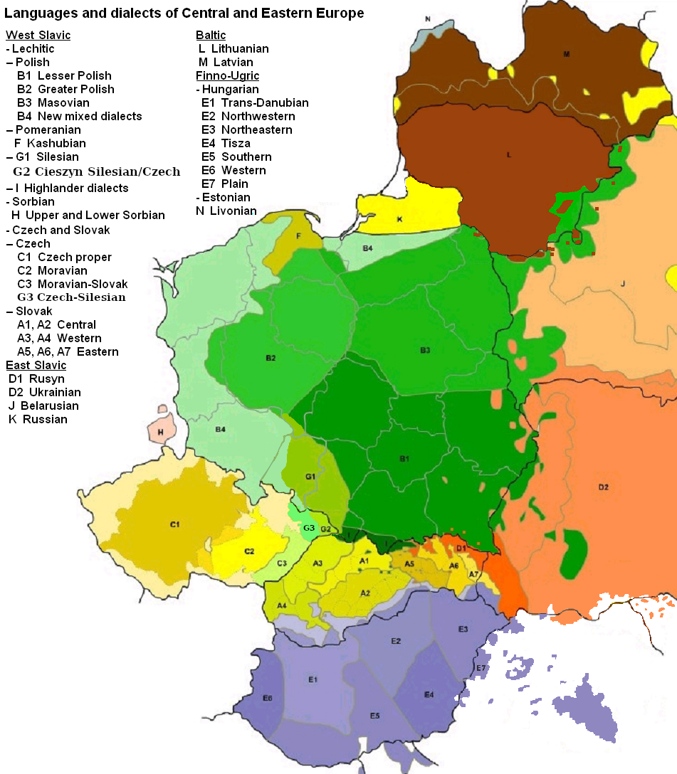
English: Map of languages and dialects of Central and Eastern Europe
Polski: Języki i dialekty Europy Srodkowo-Wschodniej
Deutsch: Legende:
|
||
| Дата | |||
| Ҫӑлкуҫ |
Хӑвӑрӑн ӗҫ |
||
| Автор | |||
| Другие версии |
|

|
Это изображение неизвестного типа «linguistic map» желательно воссоздать или аккуратно преобразовать в векторный формат SVG. Это даёт несколько преимуществ, прочитать о которых подробнее вы можете на странице Commons:Media for cleanup. Если вам уже сейчас доступна векторная версия данного изображения, загрузите её, пожалуйста, а затем замените этот шаблон на следующий: {{Vector version available|Имя загруженного файла.svg}}.
|
Лицензилени

|
Ку документа Ирӗклӗ программа хатӗрӗсен фончӗ вырнаҫтарнӑ GNU Free Documentation License 1.2 версийӗпе е каяраххипе килӗшӳллӗн хуплашкан пӗрремӗш тата юлашки страницӑри улшӑнми пайсемсемпе текстсемсӗр копилеме, сарма тата/е улӑштарма юрать. Лицензи копине GNU Free Documentation License ятлӑ пая вырнаҫтарнӑ. |
| Ку файл Creative Commons Attribution-Share Alike 3.0 Unported лицензипе мкилӗшӳллӗн сарӑлать. | ||
| Атрибуци: Zaragoza, Kpalion, Dellijks | ||
| ||
| Этот признак лицензирования был добавлен к этому файлу как часть обновления лицензии GFDL. |
Исходный журнал загрузок
This image is a derivative work of the following images:
- File:Languages_of_CE_Europe.PNG licensed with GFDL
- 2008-08-25T20:42:18Z Kpalion 951x1088 (1053557 Bytes) {{Information |Description={{en|Map of languages and dialects of Central and Eastern Europe}} |Source=*[[:Image:Jezyki_i_dialekty_Europa_Srodkowo_Wsch..jpg|]] |Date=2008-08-25 20:40 (UTC) |Author=*derivative work: ~~~ *[[:Ima
Файл историйĕ
Вӑхӑт ҫине пуссан, ун чухнехи версине пӑхма пулать.
| Дата/Вăхăт | Миниатюра | Калӑпӑш | Хутшăнакан | Асăрхав | |
|---|---|---|---|---|---|
| хальхи | 06:47, 17 Ҫурла уйӑхӗн 2019 | | 951 × 1088 (769 Кб) | D T G | G1 - changed western border (compare my other map: File:Gwary śląskie wg Zaręby.png - sources there); G2 - changed name and classification (this was part of the Polish Cieszyn Silesian, after 1920 evolving towards Czech, but it was absurd that it would be classified as Czech when to South-West was just G1, not differentiated from G1 in Poland! I repeat it was absurd!, therefore I created G3, see below); G3 - created Czech-Silesian also know as Lach dialects, up to 1980s regarded by some... |
| 07:42, 17 Ҫурла уйӑхӗн 2015 |  | 951 × 1088 (928 Кб) | Winnetou14 | Reverted to version as of 19:28, 13 September 2009 | |
| 23:11, 11 Чӳк уйӑхӗн 2009 |  | 951 × 1088 (697 Кб) | Alex Tora | {{Information |Description= |Source={{own}} |Date= |Author=Alex Tora |Permission= |other_versions= }} | |
| 19:28, 13 Авӑн уйӑхӗн 2009 |  | 951 × 1088 (928 Кб) | Scooter20 | Fixed Hungarian & Ukrainian in Romania, Ukrainian in Moldova and Romanian in Hungary and Ukraine | |
| 22:16, 19 Утӑ уйӑхӗн 2009 |  | 951 × 1088 (982 Кб) | Dellijks | {{Information |Description={{en|Map of languages and dialects of Central and Eastern Europe}}{{pl|Języki i dialekty Europy Srodkowo-Wschodniej}} {{de|-> * B1 - Kleinpolnisch * B2 - Großpolnisch * B3 - Masowisch * B4 - Hochpolnisch * F - Kaschubisch * G1 |
Файлпа усă курни
Ку файлпа ҫак 1 страницӑра усӑ курнӑ:
Файлпа глобаллӑ усӑ курасси
Ку файлпа ҫак викисенче усӑ курнӑ:
- af.wikipedia.org усӑ курасси
- als.wikipedia.org усӑ курасси
- am.wikipedia.org усӑ курасси
- ang.wikipedia.org усӑ курасси
- an.wikipedia.org усӑ курасси
- arz.wikipedia.org усӑ курасси
- ast.wikipedia.org усӑ курасси
- bo.wikipedia.org усӑ курасси
- br.wikipedia.org усӑ курасси
- csb.wikipedia.org усӑ курасси
- cs.wikipedia.org усӑ курасси
- da.wikipedia.org усӑ курасси
- de.wikipedia.org усӑ курасси
- diq.wikipedia.org усӑ курасси
- el.wikipedia.org усӑ курасси
- en.wikipedia.org усӑ курасси
- en.wiktionary.org усӑ курасси
- eo.wikipedia.org усӑ курасси
- eu.wikipedia.org усӑ курасси
- frr.wikipedia.org усӑ курасси
- fr.wikipedia.org усӑ курасси
- fur.wikipedia.org усӑ курасси
- fy.wikipedia.org усӑ курасси
- gd.wikipedia.org усӑ курасси
- he.wikipedia.org усӑ курасси
- hr.wikipedia.org усӑ курасси
- hsb.wikipedia.org усӑ курасси
- hy.wikipedia.org усӑ курасси
- incubator.wikimedia.org усӑ курасси
- ka.wikipedia.org усӑ курасси
- ko.wikipedia.org усӑ курасси
- la.wikipedia.org усӑ курасси
- mg.wikipedia.org усӑ курасси
- ms.wikipedia.org усӑ курасси
- nl.wikipedia.org усӑ курасси
- pnb.wikipedia.org усӑ курасси
Ку файлпа глобальлӗ епле усӑ курнине пӑх.